In last week’s post, I discussed how a few places we have
visited have created programs designed to teach certain audiences about their subject,
be that the history of jute or the development of bridges. This week my focus
is still on education, but in a more general sense: how can learning spaces outside
the classroom affect what and how we learn?
Consider my expedition to Siccar Point, arguably the most
significant geological outcrop in the world. It was here, in 1788, where James
Hutton found proof of his theories of the geologic unconformity (a gap in the geologic
record) and his ideas about deep time. In the classroom, thousands of miles
away in West Lafayette, I learned the facts about Siccar Point in the context
of the history of geology, with a few interesting pictures to illustrate the
point. I can remember thinking “that’s a nifty outcrop,” my professor (perhaps
jokingly, perhaps not- it was sometimes hard to tell) say that geologists have
a religious experience when they visit this site, and not much else. When the
opportunity arose to actually visit this mecca of geology, I knew that it was
important, but had almost no idea what I would actually learn from the
experience.
Gaining access to the point was both more and less difficult
than I expected. More, because I had misinterpreted the online directions I had
obtained and ended up walking eight miles instead of one and a half, and less
because there was a significant number of path markers and “you are here” type
maps along the way. The Coastal Path walk itself was incredibly beautiful, with
views from the cliff tops over the North Sea for most of the journey.
 |
| The map at the head of the Coastal Path. Photo by author. |
 |
| The cliffs on part of the Coastal Path. Photo by author. |
t the trailhead marking the location of Siccar Point, there
was an interpretive sign explaining just why in the world this location is
important, and why you should visit. It summarized Hutton’s findings, and
described how those findings went on to affect the development of geology and
of science in general. While this information wasn’t new to me, I felt that
just by reading it in this setting, less than a kilometer from the point
itself, made it more significant.
 |
| The first interpretive sign. Photo by author. |
After a tense ten minute walk through a pasture in which I
was forced to dodge innumerable piles of cow leavings, I found a second sign,
this one specifically discussing the geology of Siccar Point. It described the
order in which the geologic events occurred and how we know those events occurred.
Again, I had already been exposed to this information in class, but now that I
was just a few hundred feet from this historic site, it suddenly had more
weight. What I was about to see was history, and it was personal. This was one
of the reasons I applied for this study abroad in the first place, and the fact
that I was actually there, at that moment, made the information I already knew
become personal as well.
 |
| The second interpretive sign. Photo by author. |
And then, finally, I climbed down the last hill and got my
first view of Siccar Point. There is nothing quite like being somewhere you
have seen in pictures, read about in textbooks, known that, although you might
want to get there sometime during your life, it is probably out of your reach,
and then suddenly you actually do get
there, and realize that the pictures don’t do the place any justice and the
textbook descriptions suddenly seem so clinical and meaningless. One of Hutton’s
traveling companions remarked that “the mind seemed to grow giddy by looking so
far back into the abyss of time” as he described the scene at the point. When I
first heard this, I thought that while it probably did feel significant, to say
that it caused giddiness was probably an exaggeration. I was wrong. I spun
around, trying to take it all in at once. I hopped from rock to rock, knowing that
this was exactly where Hutton had
been and what he had seen, and even though that was 226 years in the past, it
was less than a moment compared to the true age of this place. I touched the
unconformity, just because I wanted to see what 55 million years felt like. And
I took my one (and only) selfie for this six week trip with Siccar Point in the
background. I did, in fact, become giddy.
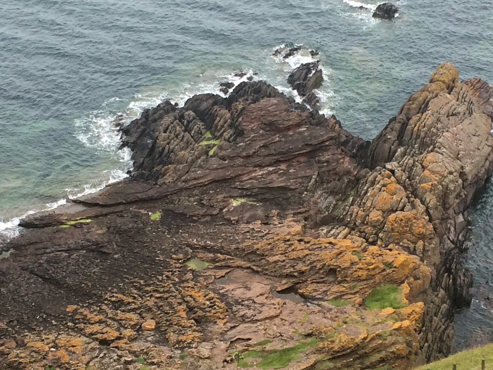 |
| Siccar Point from above. Photo by author. |
 |
| Panorama of the area. Photo by author. |
 |
| Some of the folding is visible here, as well as the more horizontal sandstone layers. Photo by author. |
 |
| Hutton's Unconformity (55My). Photo by author. |
 |
| Beds folded nearly vertical. Photo by author. |
 |
| The view looking back towards land. photo by author. |
 |
| The all-important selfie! Photo by devilishly hansom author. |
Actually being there, seeing this with my own eyes and
reading the signs along the way, allowed me to understand the idea of deep time
in a way that I never had before. It was an idea, an abstract concept that I
understood but didn’t really get. I
get it now. Thinking about deep time still makes me dizzy, but now I understand
it not as a sense of confusion, but one of vertigo as I stand at the top of a
cliff with no base, looking down into a past so distant as to be unknowable
except for the evidence that survived hundreds of millions of years so that I
could stand there on the shore of the North Sea in Scotland with my mouth open,
speechless.
No comments:
Post a Comment